
If you’re looking for the best handheld GPS devices for hiking and overlanding in 2025, I recommend checking out rugged options like Garmin GPSMAP 64sx and GPSMAP 65s, which support multiple satellite systems and have durable, weather-resistant designs. Devices like the Garmin inReach Mini 2 add satellite messaging and SOS features for safety. Whether you want basic navigation or advanced mapping, there’s a device for you. Keep going to discover detailed options that match your adventure style.
Key Takeaways
- Consider rugged, weather-resistant designs like Garmin GPSMAP 64sx and eTrex® SE for durability in tough outdoor conditions.
- Evaluate display visibility and satellite support, prioritizing sunlight-readable screens and multi-GNSS compatibility for accurate positioning.
- Look for advanced mapping and routing features, including preloaded TopoActive maps and terrain navigation capabilities.
- Check battery life and power options, favoring devices with extended usage, rechargeable batteries, or long-lasting AA battery support.
- Assess additional features like satellite messaging, emergency SOS, and connectivity with Garmin Explore for comprehensive outdoor safety and communication.

Garmin 010-02256-00 eTrex 22x, Rugged Handheld GPS Navigator, Black/Navy
Explore confidently with the reliable handheld GPS
As an affiliate, we earn on qualifying purchases.
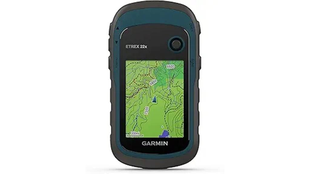
If you’re looking for a reliable, rugged GPS device that can handle tough outdoor conditions, the Garmin eTrex 22x is an excellent choice. Its compact, durable design makes it perfect for hiking, biking, or overlanding. The 2.2-inch sunlight-readable color display ensures I can see the screen clearly in bright sunlight. It comes preloaded with Topo Active maps, complete with roads and trails, and supports GPS and GLONASS for dependable tracking. With 8 GB of internal memory and expandable storage, I can load plenty of maps. Plus, the device’s long battery life of up to 25 hours keeps me going on extended adventures.
Best For: outdoor enthusiasts, hikers, bikers, and overlanders seeking a rugged, reliable GPS device with detailed maps and long battery life.
Pros:
- Durable, compact design suitable for tough outdoor conditions
- Bright 2.2-inch sunlight-readable color display for clear viewing in various lighting
- Preloaded with Topo Active maps and supports GPS/GLONASS for accurate navigation
Cons:
- Limited internal storage (8 GB) may require frequent map management
- Uses 2 AA batteries, which may need replacement during extended trips
- Smaller screen size compared to some advanced navigational devices

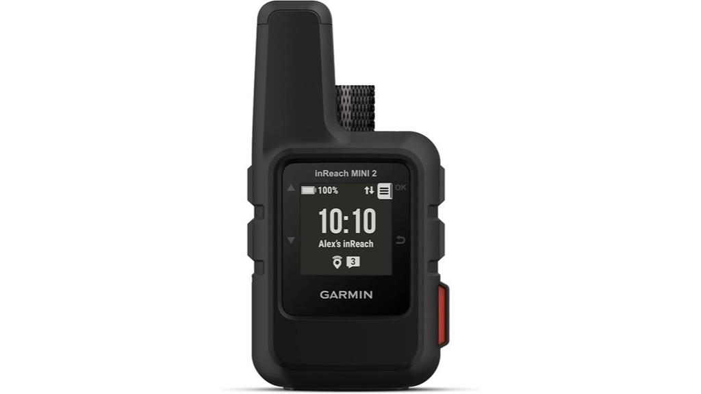
Garmin inReach Mini 2, Lightweight and Compact Satellite Communicator, Hiking Handheld, Orange - 010-02602-00
Compact, lightweight satellite communicator enables two-way messaging and interactive SOS globally (Active satellite subscription required. Some jurisdictions regulate...
As an affiliate, we earn on qualifying purchases.
Garmin inReach Mini 2 Satellite Communicator
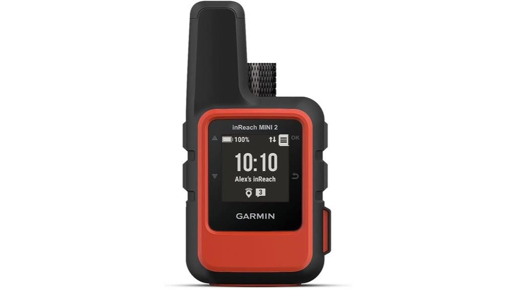
The Garmin inReach Mini 2 Satellite Communicator is an ideal choice for outdoor adventurers who need reliable, two-way satellite messaging and emergency SOS capabilities in remote locations. Compact and lightweight at just over 3.5 ounces, it packs features like interactive SOS, TracBack navigation, and a color touchscreen with a 176 x 176 resolution. Bluetooth connects it to Garmin devices and smartphones, while its water resistance guarantees durability. With a battery life of up to 14 days in 10-minute tracking mode, it’s perfect for extended trips. Syncing with the Garmin Explore app enhances trip planning, mapping, and waypoint sharing, making it a versatile companion for outdoor explorers.
Best For: outdoor adventurers and remote travelers who need reliable satellite communication, emergency SOS, and navigation features in challenging environments.
Pros:
- Compact, lightweight design ideal for portability during outdoor activities
- Up to 14 days of battery life in 10-minute tracking mode for extended use
- Interactive SOS and TracBack routing enhance safety and navigation in remote locations
Cons:
- Requires an active satellite subscription for full functionality
- Limited touchscreen resolution may affect visibility in bright sunlight
- Compatibility depends on pairing with Garmin devices or smartphones via Bluetooth

Garmin 010-00970-00 eTrex 10 Worldwide Handheld GPS Navigator
Rugged handheld navigator with preloaded worldwide basemap and 2.2 inch monochrome display
As an affiliate, we earn on qualifying purchases.
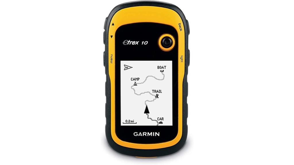
For hikers and overlanders seeking a reliable, straightforward GPS, the Garmin 010-00970-00 eTrex 10 is an excellent choice. Its rugged design and waterproof rating (IPX7) guarantee durability in tough conditions. The device features a 2.2-inch monochrome display and preloaded worldwide basemap, making navigation simple anywhere. With WAAS-enabled GPS and GLONASS support, it quickly locks onto signals even in challenging environments. Powered by two AA batteries, it can last up to 20 hours. It also supports paperless geocaching and connects with Garmin accessories, making it a versatile, dependable tool for outdoor adventures.
Best For: hikers, overlanders, and outdoor enthusiasts seeking a durable, easy-to-use GPS with reliable signal acquisition.
Pros:
- Rugged waterproof design (IPX7) suitable for harsh outdoor conditions
- Preloaded worldwide basemap simplifies navigation anywhere
- Long battery life of up to 20 hours with AA batteries
Cons:
- Monochrome display may be less visually engaging than color screens
- Limited advanced mapping features for complex navigation needs
- Requires AA batteries, which may be less convenient than rechargeable options

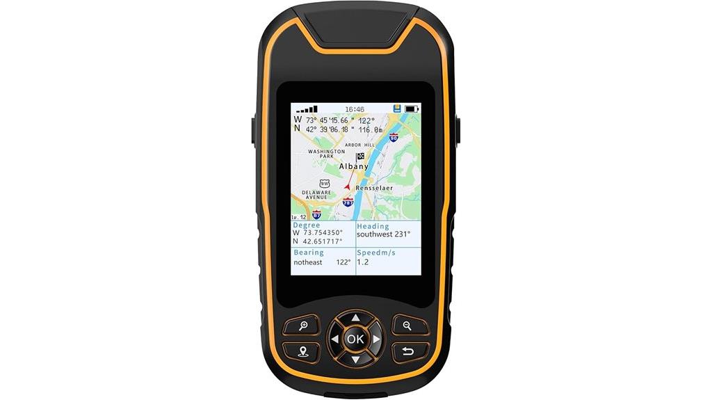
Handheld GPS for Hiking, Rugged and Waterproof Handheld GPS Navigator, 3.2" Sunlight Readable Screen, Compact Satellite Handheld GPS with USA Topo Map, Multi-GNSS Support, Extra Battery Life
Excellent Satellite Support: Access Multi-GNSS navigation satellite systems (GPS+GALILEO+BEIDOU+QZSS) for improved position accuracy,location precision withih 5 ft, allows...
As an affiliate, we earn on qualifying purchases.
Handheld GPS for Hiking, Rugged Waterproof Navigator with Sunlight Readable Screen

When tackling outdoor adventures in bright sunlight, a handheld GPS with a sunlight-readable screen becomes an essential tool. I rely on this rugged waterproof navigator because its 3.2-inch color display stays clear even under intense glare. Compact and lightweight at just 7.2 ounces, it’s easy to carry on hikes. Supporting Multi-GNSS systems like GPS, GALILEO, BEIDOU, and QZSS, it offers precise positioning within five feet, even in challenging environments. With 16GB of internal memory, it stores thousands of waypoints, routes, and tracks. Its long-lasting 24-hour battery ensures I stay connected without worrying about power during extended trips.
Best For: outdoor enthusiasts and hikers who need a rugged, waterproof GPS with a sunlight-readable screen for reliable navigation in challenging outdoor environments.
Pros:
- Supports Multi-GNSS systems (GPS, GALILEO, BEIDOU, QZSS) for high-accuracy positioning even in difficult conditions.
- Long battery life of up to 24 hours with a rechargeable 4,000mAh battery, ideal for extended outdoor trips.
- Compact, lightweight design with a bright 3.2-inch sunlight-readable display, easy to carry and view in bright sunlight.
Cons:
- Indoor use may result in no satellite signal; optimal performance requires outdoor environments.
- Base map is limited to the USA; additional maps require download or support.
- Price and availability are subject to change, and some users may need to purchase extra maps or accessories.
Garmin GPSMAP 65 Handheld GPS with Expanded Satellite Support

If you’re steering challenging terrains where accurate positioning matters most, the Garmin GPSMAP 65 stands out due to its expanded satellite support. Its 2.6-inch sunlight-readable color display makes navigation clear in any conditions, and the button-operated design ensures durability. With multi-band technology and support for global GNSS systems, it delivers precise location data even in steep, urban, or forested areas. It includes routable TopoActive maps and a federal land map for the U.S., plus compatibility with Garmin Explore for managing your routes and waypoints. This rugged device is perfect for serious hikers and overlanders needing reliable, detailed navigation.
Best For: outdoor enthusiasts such as hikers, overlanders, and adventurers who require reliable and precise navigation in challenging environments.
Pros:
- Expanded global satellite support with multi-band technology for enhanced accuracy in difficult terrains.
- Durable, button-operated design with a sunlight-readable 2.6-inch color display for easy viewing in all conditions.
- Includes detailed TopoActive maps and compatibility with Garmin Explore for comprehensive route and waypoint management.
Cons:
- Requires a compatible smartphone for full management of routes and statistics.
- Limited to U.S. public land maps unless additional maps are purchased or added.
- The device’s rugged design may be bulkier compared to some compact handheld GPS options.
Garmin eTrex 32x, Rugged Handheld GPS Navigator

The Garmin eTrex 32x stands out as a top choice for outdoor enthusiasts who need a durable, reliable GPS in rugged environments. Its 2.2-inch sunlight-readable color display guarantees clear navigation even in bright conditions. Preloaded with Topo Active maps, it offers detailed routing for hiking and cycling. Supporting both GPS and GLONASS satellites, it tracks accurately in tough terrains. The device includes a 3-axis compass, barometric altimeter, and 8 GB of internal storage, plus a micro SD slot for extra maps. With up to 25 hours of battery life on AA batteries, it’s built to last through long adventures.
Best For: outdoor enthusiasts and adventurers seeking a durable, accurate GPS device for hiking, cycling, and rugged terrain exploration.
Pros:
- Rugged design built to withstand tough outdoor conditions
- Supports both GPS and GLONASS for enhanced tracking accuracy
- Long battery life of up to 25 hours with AA batteries
Cons:
- Relatively small 2.2-inch display may not suit all users’ preferences
- Limited internal storage of 8 GB, requiring micro SD cards for additional maps
- No touchscreen capability; navigation relies on physical buttons
Garmin GPSMAP 64sx Handheld GPS with TopoActive Maps
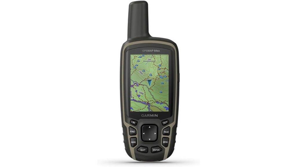
For avid hikers and overlanders seeking durability and reliable navigation, the Garmin GPSMAP 64sx stands out with its rugged, water-resistant design and button-operated interface. Its 2.6-inch sunlight-readable color display makes maps easy to see in bright conditions. Preloaded with TopoActive maps for the U.S. and Australia, it offers detailed routing for trails, roads, cycling, and hiking. The high-sensitivity receiver with quad helix antenna supports GPS, GLONASS, and Galileo satellites for accurate positioning. With a 3-axis compass, barometric altimeter, Bluetooth, and ANT+ connectivity, plus up to 16 hours of battery life, it’s a versatile, dependable companion for any outdoor adventure.
Best For: outdoor enthusiasts, hikers, and overlanders who need a durable, reliable GPS with detailed maps and multi-satellite support.
Pros:
- Rugged, water-resistant design suitable for tough outdoor conditions
- Preloaded TopoActive maps with routing for trails, roads, and cycling
- Supports multiple satellite systems (GPS, GLONASS, Galileo) for accurate positioning
Cons:
- Slightly limited display size at 2.6 inches may affect detailed viewing
- No touchscreen interface, relying on button operation which may be less intuitive for some users
- Battery life of up to 16 hours may require extra power management during long expeditions
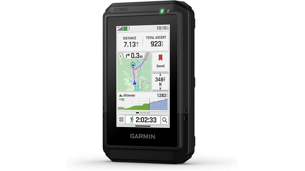
Garmin eTrex® SE GPS Handheld Navigator
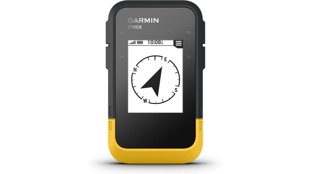
The Garmin eTrex® SE GPS Handheld Navigator stands out as an ideal choice for outdoor enthusiasts who need reliable navigation in challenging conditions. Its 2.2-inch high-resolution, sunlight-readable display guarantees clear visibility even in bright sunlight. With support for multiple satellite systems like GPS, GLONASS, Galileo, BeiDou, and QZSS, it performs well in tough environments. The device offers up to 168 hours of battery life in standard mode and 1,800 hours in expedition mode, perfect for extended adventures. Bluetooth and USB connectivity allow seamless pairing with the Garmin Explore app, enabling trip planning, weather updates, and cache management on the go.
Best For: outdoor enthusiasts and adventurers who require a durable, highly accurate GPS device for challenging environments and extended trips.
Pros:
- Supports multiple satellite systems (GPS, GLONASS, Galileo, BeiDou, QZSS) for reliable tracking in tough conditions.
- Long battery life up to 1,800 hours in expedition mode, ideal for extended outdoor activities.
- Waterproof (IPX7 rated) and rugged design, suitable for all weather conditions.
Cons:
- Uses AA batteries which need to be purchased separately, potentially adding to ongoing costs.
- Small 2.2-inch display may be less ideal for users preferring larger screens.
- Limited internal storage without cloud or app integration for offline map storage.
Garmin GPSMAP 65s Handheld GPS with Altimeter and Compass
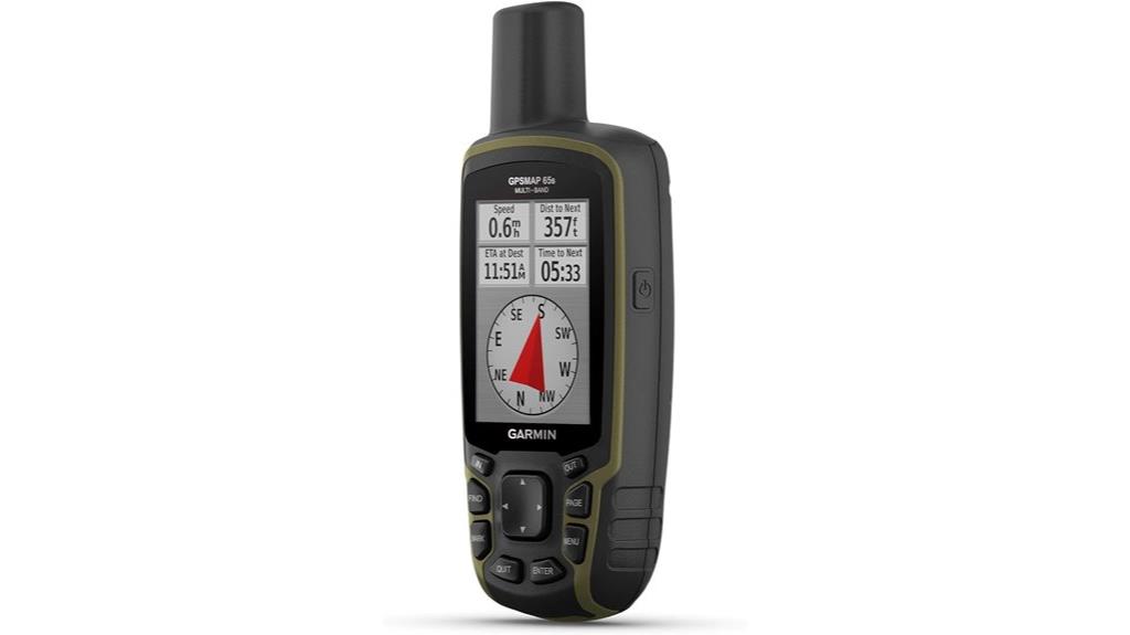
If you need a reliable handheld GPS that performs well in challenging environments, the Garmin GPSMAP 65s stands out with its expanded GNSS support and multi-band technology, ensuring precise navigation even in dense forests, urban canyons, or steep terrains. Its 2.6-inch sunlight-readable color display makes data easy to see outdoors. It includes routable TopoActive maps and a federal land map (U.S. only), plus a 3-axis compass and barometric altimeter for accurate orientation. Compatible with Garmin Explore, it lets me manage routes and waypoints effortlessly. Designed for versatile, go-anywhere navigation, the GPSMAP 65s is a dependable choice for demanding outdoor adventures.
Best For: outdoor enthusiasts and adventurers who need a reliable, accurate handheld GPS capable of functioning in challenging environments like dense forests, urban canyons, and steep terrains.
Pros:
- Expanded GNSS support and multi-band technology for high-precision navigation in difficult conditions
- Bright 2.6-inch sunlight-readable color display for easy outdoor viewing
- Includes routable TopoActive maps and federal land map (U.S. only), plus compass and barometric altimeter for reliable orientation
Cons:
- May require a smartphone to fully utilize Garmin Explore app features
- Slightly larger size might be less pocket-friendly for some users
- Limited to U.S. federal land maps unless additional maps are purchased
A6 Handheld GPS for Hiking
Designed specifically for hikers who need reliable navigation in challenging terrains, the A6 Handheld GPS offers high accuracy and rugged durability. Its IP65 waterproof and dustproof rating guarantees it withstands tough conditions, while the support for multiple GNSS systems (GPS, GLONASS, BEIDOU, QZSS) enhances precision in difficult environments. The 2.4-inch sunlight-readable color display is easy to see outdoors, and the non-slip button design provides easy operation. Although it doesn’t come with preloaded maps, it’s perfect for waypoint management, route tracking, and guiding you back if you get lost. Powered by a rechargeable battery, it lasts up to 20 hours, making it a reliable companion on any hike.
Best For: hikers and outdoor enthusiasts who need a rugged, accurate GPS device for navigation in challenging terrains without relying on preloaded maps.
Pros:
- Supports multiple GNSS systems (GPS, GLONASS, BEIDOU, QZSS) for enhanced positioning accuracy.
- Rugged and waterproof (IP65 rated), ideal for tough outdoor conditions.
- Long battery life of up to 20 hours, suitable for extended outdoor activities.
Cons:
- Does not come with preloaded maps, requiring users to manually manage waypoints and routes.
- Customer ratings are relatively low (2.9 out of 5 stars from 25 reviews), indicating mixed user experiences.
- Slightly larger and heavier (8 oz) compared to some compact GPS devices, which might affect portability.
Garmin eTrex Touch Rugged GPS Handheld Navigator
For outdoor enthusiasts seeking a durable and feature-rich handheld GPS, the Garmin eTrex Touch Rugged GPS Navigator stands out with its bright 3-inch high-resolution color touchscreen and rugged build. It’s designed to handle tough weather, thanks to its IP67 water rating, and includes detailed maps for roads and trails, showing terrain, elevations, and points of interest. The device supports multi-band GPS for accuracy and offers features like popularity routing and ascent planning. With up to 130 hours of battery life and seamless Bluetooth and USB connectivity, it’s perfect for hiking, trail riding, and outdoor adventures. Its versatility and durability make it a top choice for explorers in 2025.
Best For: outdoor enthusiasts and explorers seeking a rugged, high-accuracy handheld GPS with detailed mapping and long battery life for hiking, trail riding, and outdoor adventures.
Pros:
- Durable IP67 water-resistant design suitable for harsh weather conditions
- Bright 3-inch high-resolution color touchscreen for easy navigation and map viewing
- Supports multi-band GPS and offers features like popularity routing and ascent planning for enhanced navigation
Cons:
- Additional accessories and premium maps are sold separately, increasing overall cost
- May have a learning curve for users unfamiliar with GPS devices and advanced features
- Limited internal storage; reliance on external microSD cards for extensive map data
Garmin inReach Mini 2 Satellite Communicator
The Garmin inReach Mini 2 Satellite Communicator stands out as an excellent choice for serious outdoor enthusiasts who need reliable two-way messaging and emergency assistance in remote areas. Its compact, lightweight design makes it easy to carry on any adventure, while features like global messaging, interactive SOS, and TracBack routing ensure safety and navigation. It pairs seamlessly with Garmin wearables and the Explore app for trip planning, maps, and waypoints. With a battery life of up to 14 days, it’s perfect for extended trips. Keep in mind, an active satellite subscription is required for communication and emergency services. This device combines durability with essential connectivity.
Best For: outdoor enthusiasts and adventurers who require reliable satellite communication, navigation, and emergency assistance in remote areas.
Pros:
- Compact and lightweight design for easy portability during outdoor activities
- Up to 14-day battery life supports extended trips and adventures
- Seamless pairing with Garmin devices and Explore app enhances trip planning and mapping
Cons:
- Requires an active satellite subscription for full functionality, adding ongoing costs
- No built-in display for real-time mapping or messaging, relying on paired devices or apps
- Limited to satellite coverage; may be regulated or restricted in certain jurisdictions
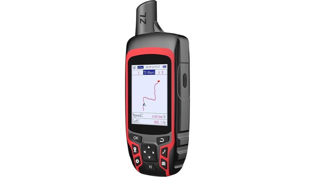
ZL180 Handheld GPS for Surveying

If you need precise surveying tools that perform reliably outdoors, the ZL180 Handheld GPS stands out with its dual GPS and GLONASS satellite systems, ensuring strong global coverage. It supports fast positioning with an area measurement error of just 0.003 acres. Its 2.4-inch backlit LCD display makes it easy to view measurements directly. Weighing around 180 grams, its ergonomic design fits comfortably in hand. Perfect for land surveying tasks like ranches, gardens, and parking lots, it offers four measurement modes for areas and distances. Remember, ideal results depend on outdoor use to acquire satellite signals, and holding the device horizontally improves accuracy.
Best For: outdoor land surveyors and property owners needing reliable, high-precision measurements in open outdoor environments.
Pros:
- Dual satellite systems (GPS + GLONASS) for enhanced global coverage and signal reliability
- Compact, lightweight design with ergonomic grip for easy handling during extended use
- Supports multiple measurement modes suitable for various land surveying tasks
Cons:
- Cannot save waypoints or navigation data, limiting route planning capabilities
- Performance heavily dependent on outdoor conditions; indoor use is not recommended
- Altitude readings fluctuate with satellite signals, which may affect elevation accuracy
Garmin GPSMAP 67i Rugged GPS Handheld with inReach® Satellite Technology
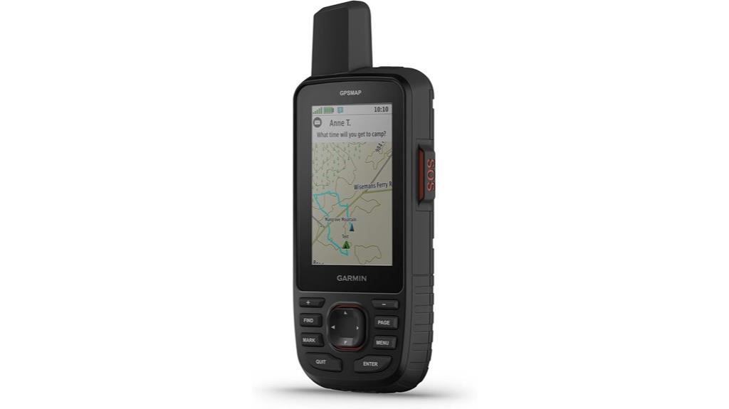
Designed for rugged outdoor adventures, the Garmin GPSMAP 67i stands out with its built-in inReach® satellite technology, allowing me to send and receive messages even in remote areas lacking cell service. Its large, sunlight-readable 3-inch display makes navigation clear, while a compact, durable design and 8.1-ounce weight guarantee it’s easy to carry. With impressive battery life—up to 165 hours in tracking mode—I can rely on it for extended trips. It supports preloaded TopoActive maps, satellite imagery, and multi-band GNSS sensors for precise navigation. Plus, the interactive SOS and Garmin Response℠ offer peace of mind, making it a top choice for serious explorers.
Best For: outdoor enthusiasts and adventurers seeking a durable, feature-rich GPS device with satellite communication and emergency capabilities.
Pros:
- Rugged, durable design suitable for challenging outdoor environments
- Extended battery life with up to 165 hours in tracking mode
- Built-in inReach® satellite technology for reliable messaging and emergency SOS
Cons:
- Subscription required for satellite communication and some mapping features
- Slightly heavier compared to basic handheld GPS units at 8.1 ounces
- Limited to specific accessories and map downloads via Wi-Fi or Garmin Explore™ platform
A8 Handheld GPS for Hiking
When choosing a reliable GPS device for hiking, the A8 Handheld GPS stands out thanks to its support for multiple GNSS systems like GPS, GALILEO, BEIDOU, and QZSS, which guarantees pinpoint accuracy even in challenging environments. Its lightweight, waterproof design features a 3.2-inch sunlight-readable color screen, making visibility easy in bright conditions. With up to 24 hours of battery life and 16GB internal memory, it can store thousands of waypoints, routes, and tracks. The device offers essential navigation tools like waypoint setting, route planning, and track recording, ensuring you stay on course and find your way back with confidence.
Best For: outdoor enthusiasts, hikers, and adventurers seeking a durable, high-accuracy GPS device for challenging environments.
Pros:
- Supports multiple GNSS systems (GPS, GALILEO, BEIDOU, QZSS) for superior accuracy
- Waterproof and lightweight design with a bright, sunlight-readable 3.2-inch screen
- Long battery life of up to 24 hours with ample internal storage for waypoints, routes, and tracks
Cons:
- Customer ratings are average, with some users reporting issues or dissatisfaction
- Limited to outdoor signal reception; indoor use may be unreliable
- First available for purchase in January 2025, indicating it may be a new release with limited user feedback
Factors to Consider When Choosing Handheld GPS for Hiking for Overlanding
When choosing a handheld GPS for overlanding, I focus on key factors like satellite compatibility and screen readability to guarantee reliable navigation in tough conditions. Battery life and durability standards are also vital, since I need my device to last through long trips and handle rough terrain. Finally, mapping features can make or break your experience, so I consider how detailed and user-friendly they are for your adventures.
Satellite Compatibility
Choosing a handheld GPS with robust satellite compatibility is vital for reliable navigation in challenging environments. I look for devices that support multiple satellite systems like GPS, GLONASS, Galileo, and BeiDou, ensuring better coverage in dense forests, urban areas, or rugged terrain. Multi-band GNSS technology reduces positional errors and shortens lock times, which is essential when signals are obstructed. I also verify that the device can connect with satellite communication tools like inReach for emergency use and two-way messaging. Additionally, I check regional compatibility, ensuring the device’s satellite support meets local regulations and subscription requirements. This extensive satellite compatibility guarantees that I stay accurately positioned and connected, no matter where my adventures take me.
Screen Readability
A handheld GPS’s screen clarity can make or break your navigation experience, especially in bright outdoor conditions. Look for a sunlight-readable display with high brightness and contrast to guarantee visibility even under direct sunlight. Higher screen resolution, such as 240 x 320 pixels or more, improves detail and makes maps easier to interpret at a glance. Anti-glare coatings or matte screens help reduce reflections, further enhancing readability outdoors. Larger screens, generally 2.2 inches or bigger, provide a broader view of maps and data, making navigation more intuitive. Additionally, adjustable brightness settings and consistent backlighting help maintain clarity across various lighting conditions. Prioritizing these factors ensures you won’t struggle to see your maps when it matters most.
Battery Endurance
Extended battery life is crucial for overlanding trips, where access to power sources can be limited. Many GPS devices can provide 20 to 25 hours of continuous use on standard batteries, which is essential for multi-day adventures. Some units support rechargeable batteries that can last 24 hours or more, reducing the need for frequent replacements. Features like low power consumption modes or expedition modes can extend operational time during extended outings. External power options such as portable power banks or solar panels are also valuable, letting you recharge devices in the field. Keep in mind that environmental factors like cold weather can drain batteries faster. Choosing a GPS with robust power management features ensures your device stays reliable, even in challenging conditions.
Durability Standards
When selecting a handheld GPS for overlanding, prioritizing durability standards is essential because outdoor conditions can be unpredictable and tough on equipment. Look for devices with ratings like IP67 or IPX7, which guarantee water and dust resistance, so your device survives rain, mud, or snow. Rugged construction with reinforced casings and shock resistance shields against impacts and drops that happen on rugged trails. Check the operating temperature range to ensure reliable performance in extreme hot or cold environments. Sealed battery compartments help prevent moisture ingress during extended trips. Additionally, compliance with military standards like MIL-STD-810 guarantees the device can withstand vibration, humidity, and thermal shocks typical of overlanding adventures. These standards are critical for ensuring your GPS endures the harsh conditions you’ll face.
Mapping Features
Choosing the right handheld GPS for hiking and overlanding hinges on its mapping capabilities, which directly impact navigation accuracy and ease of use. I look for devices preloaded with topographical maps and routable roads, helping me navigate remote areas confidently. Supporting multiple satellite systems like GPS, GLONASS, Galileo, or QZSS ensures reliable positioning even in challenging environments. Customizable mapping options are vital; being able to download additional maps or update existing ones keeps my navigation current. Features like detailed terrain, elevation data, and points of interest improve trip planning and situational awareness. Finally, a clear, sunlight-readable display is essential for visibility in outdoor lighting. These mapping features collectively enhance my navigation experience, especially in unpredictable terrains.
Operating Ease
A handheld GPS is only as good as its ease of use, especially when you’re steering unfamiliar terrain. I look for devices with intuitive interfaces, whether it’s simple button controls or touchscreen navigation, to make operation seamless in outdoor conditions. A clear, high-contrast display that’s sunlight-readable is essential, so I can see my maps without squinting or eye strain. Preloaded maps and straightforward setup mean I can get started quickly without fussing with complicated configurations. Features like one-touch waypoints and quick access menus help me plan routes and make adjustments on the fly, saving precious time. User-friendly menus and minimal navigation steps keep me confident during hikes, preventing confusion and letting me focus on the trail ahead.
Size and Weight
Lightweight and compact design are essential factors when selecting a handheld GPS for hiking or overlanding, as they directly impact how comfortably I can carry it on long journeys. Devices under 8 ounces are easier to handle during extended trips, reducing fatigue without sacrificing durability. Smaller units, less than 3 inches, fit conveniently into pockets, backpacks, or mounts, minimizing bulk and making navigation less cumbersome. However, I also consider screen size; smaller devices often have less prominent displays, which can hinder readability in bright outdoor conditions. Additionally, I pay attention to the overall weight, including batteries, since heavier batteries add to the total weight and affect portability. Finding the right balance between size, weight, and usability is key for a successful outdoor experience.
Connectivity Options
Connectivity options play a essential role in ensuring my handheld GPS keeps me connected and enhances my navigation capabilities during outdoor adventures. I look for devices that support Bluetooth and USB connections to easily sync with my smartphone or tablet for quick data sharing and route updates. Satellite communication features like inReach or Iridium are indispensable for two-way messaging and emergency SOS in remote areas. Supporting multiple GNSS systems—GPS, GLONASS, Galileo, QZSS—improves signal reliability in tough environments. Wireless connectivity allows me to access real-time map updates, plan routes, and manage waypoints via dedicated apps or cloud services. External accessories, like microSD card slots or external antennas, can further boost connectivity and signal reception, ensuring I stay connected no matter where I go.
Frequently Asked Questions
How Do Handheld GPS Devices Perform in Remote Areas Without Signal?
Handheld GPS devices perform well in remote areas without signal because they use satellite signals rather than cell towers. I find that most modern units have built-in maps and can store waypoints, so I can navigate confidently even offline. Just make sure your device has a full battery and relevant maps downloaded beforehand. This way, I stay on course, no matter how isolated the terrain gets.
What Are the Battery Life Differences Between Various GPS Models?
Imagine you’re hours into a trek, and your GPS’s battery dies. I’ve seen this happen to adventurers, and it’s a real risk. Battery life varies widely: some models like Garmin GPSMAP 66i last up to 35 hours, while others like the Garmin eTrex series offer around 20 hours. I always recommend carrying an extra power bank or batteries to stay safe and connected during your journey.
Can These Devices Connect to External Sensors or Accessories?
Yes, many of these GPS devices can connect to external sensors or accessories. I’ve seen models that support Bluetooth, ANT+, or USB connections, allowing you to pair with heart rate monitors, altimeters, or even satellite communicators. This connectivity enhances functionality, making your hikes or overlanding trips safer and more efficient. Just check each device’s specifications to guarantee compatibility with the sensors or accessories you want to use.
How User-Friendly Are the Interfaces for Beginners?
Think of these GPS devices like friendly guides, clear and easy to follow. For beginners, I find their interfaces quite intuitive—large buttons, simple menus, and straightforward maps. They’re designed to reduce confusion and make navigation feel like a walk in the park. I’ve seen newbies pick them up quickly, feeling confident as they explore. So yes, most models are user-friendly and ready to assist you on any adventure.
Do These GPS Units Support Offline Map Downloads for Offline Navigation?
Yes, many of these GPS units support offline map downloads, which is essential when you’re out of cell range. I’ve found that models like Garmin and Garmin-compatible devices let me preload maps beforehand, so I can navigate confidently even without internet. This feature guarantees I won’t get lost in remote areas and helps me plan my routes more effectively, especially when exploring unfamiliar terrains or overlanding.
Conclusion
No matter which GPS device you choose, remember that reliability is key—especially when you’re off the grid. I know some worry about tech failure, but investing in a rugged, feature-rich GPS with satellite support guarantees you stay safe and connected. Trust me, a dependable handheld GPS isn’t just a gadget; it’s your lifeline on those remote trails. So, pick one that suits your needs, and enjoy your adventures with confidence!